
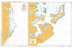
PNG 646
Approaches To Madang
Please note that all charts are nominally folded in half for storage and handling as per the marine industries standard.
If you require an unfolded copy (ie: flat for framing), please select Flat Paper, and we will organise a special print service to accomodate your request.
Description
This official Nautical Chart is produced by the Australian Hydrographic Office, and corrected fortnightly to 'Notice to Marines' by Cairns Charts & Maps. This ensures it remains compliance with Safety of Navigation requirements. This marine chart, or 'sea map', is primarily produced to support the safe navigation of commercial shipping through Australian, Papua New Guinea and Solomon Island waters.
Nautical charts depict the seabed, or bathymetry, using a variety of colours to shade the depth regions. Darker blues indicate shallower water, while light blues and white indicate deeper water. A chart will also show continuous contour lines (at varying intervals depending on the scale of the chart), 'spot depths' across the whole area, as well as different symbols indicating wrecks, shallow rocks and dangers, as well as details on lights, light houses, tides and currents.
For extensive detail on the symbology of nautical charts, the Symbols and Abbreviations used on Admiralty Charts is the definitive reference.
Yomba Island Jomba Island Jombai Island Yabob Island Jabob Island Yabob Wonad Island Wongat Island Warwin Creek Wagol River Urembo Island Ulimal Island Tausch Island Taush Island Tab Island Pig Island Tab Anchorage Tabad Island Tabat Island Sissiak Foran Sisiak Sinup Island Sinub Island Siar Island Siar Sek Island Seg Sek Harbour Alexis Harbour Alexis-Hafen Grossfurst-Alexis Hafen Sec Harbor Sek Schlangen Island Schlangan Island Schering Peninsula Kalibobo Peninsula Samin Dangan Island Saint Fidelis High School Sai Dangan Island Sae Dangan Riwo Island Ruo Island Riwo Rasch Pass Rasch Passage Pook Island Planet Rock Pana Tibun Islet Pana-Tibun Island Panu Tibun Island Panab Island Paeowa Island Ortzen Island Paeowai Island Paeowan Island Ottilien Pass Ottilien Passage Ort Nui Island Quarantine Island Nagada River Nagada Mission Nagada Harbour Freidrich Karl Harbour Friedrich Karl Harbour Mis Teachers College Mis River Mis Inlet Prince Heinrich Harbour Prinz Heinrich Harbour Siar Harbor Mis Mililat Harbour Meiro River Gauta River Megas Island Medibur Mebat Mobat Masas Island Massas Island Marrain River Malamal Island Malmal Island Malamal Anchorage Malamal Makley River Maclay River Makely River Maklay River Makley Creek Maiwara School Madang Harbour Friedrich Wilhelm Harbour Madang Friedrich Wilhelms Harbour Friedrich-Wilhelmshafen MAG Cape Kusserow Cape Kusseron Cape Kussoron Kranket Island Gragat Island Kranget Island Krankit Island Ragetta Kranket Kranget Kananam Kanaman Point Kananam Point Kanaman Island Kalibobo Point Cape Jantzen Gum River Marien River Gosem Island Kuseem Island Duad Island DLole Island D'Lole Island Danip Dallman Passage Dallman Pass Dallmann Passage Budup Bostrem Bay Bode Point Binnen Harbour Biges River Begis River Psiges Creek Psiges River Beliau Island Beliao Sai Dangan Cape Barschtsch Baitabag Mission Alexishafen Alexishaffen Alexishaven Saint Michael's Saint Michaels Saint Micheal Admosin Island Madang Airport AYMD Aeroport de Madang frwdgah madang Comfort Inn Coast Watchers COMFORT INN COAST WATCHERS Smugglers Inn Resort SMUGGLERS INN RESORT U/N Lake Timin