
NSW 8931-2N
Rock Hill
Digital Products: You will receive an email shortly after checkout containing links to download your products.
If you do not receive this email within 30min, please check your Junk / SPAM email folder, prior to contacting us.
Description
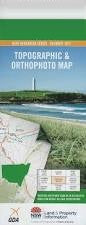
This Topographic Map is produced by the New South Wales Government.
This map is supplied in digital in PDF format, which means it can be printed at home or sent to a professional printer for a 100% scale reproduction.
At this scale, 4cm on this map represents 1km on the ground. A standard map (which is square) covers an area of approximately about 12.5km by 12.5km, with a contour interval of 10m. This map contains natural and constructed features including road and rail infrastructure, vegetation, hydrography, contours, localities and some administrative boundaries.
Annie Rowan Creek Mount Barakee Blady Grass Hill Black Cliff Creek Budgary Creek Mount Budgary Mount Cameron Cockatoo Hill Deep Pass Galah Galah Mountain Govett South Limit Hill Mackenzies Creek Main Creek Mount Mistake Natural Bridge Nayook Creek Mount Norris North Head Pommel Hill Rock Hill Sandy Cave Creek Tambo Creek Tambo Limb Tuggerah Oval Valley of The Swamps Wollangambe North Dinner Gully Dinner Creek Wollangambe Newnes Plateau Barakee Dingo Creek Derailment Hill Railmotor Ridge